|
|
|
|
|
|
|
|
|
Pegase Application : Meuse River
| Year of design: | 2011 |
|---|
| Description: | After a succesful test of trans-national simulation realised on the Chiers river (2 200 km², Meuse River tributary), the Wallonia Public Service (SPW, Be) initiated, in collaboration with the French Water Agency Rhine-Meuse (AERM, Fr), the Administration for Water Management of the Grand-Duchy of Luxemburg (AGELux, Lu) a request to the Aquapole (in 2005) to develop a trans-national application of the Pegase model on the upstream part of the Meuse River (down-to the Dutch border).
This application was extended from 2008 to 2010 to the whole international district of the Meuse River, with new stakeholders: The "Vlaamse Milieumaatshappij" (VMM, Be), the "Ministerium für Umwelt und Naturschutz des Landes Nordrhein-Westfalen" (MUNLV, De) and the "Rijkswaterstraat" (RWS, Nl).
The application covers a watershed of 35&nbps;140 km², for 13 560 km of rivers (1 319 rivers) spread as follows: -
- France, Rhine-Meuse basin: 197 rivers, 2 630 km, 7 850 km²
- France, Artois-Picardie basin: 68 rivers, 540 km, 1 100 km²
- Luxemburg: 3 rivers, 18 km, 73 km²
- Belgium, Wallonia: 638 rivers, 5 430 km, 12 050 km²
- Belgium, Flanders: 65 rivers, 550 km, 1 825 km²
- Germany: 127 rivers, 1 660 km, 4 140 km²
- Netherlands: 241 rivers, 2 720 km, 8 450 km²
|
|---|
| Basin View*: | 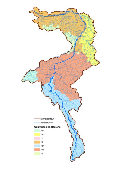
 |
|---|
| Competent Authority: | Meuse International Commission |
|---|
| Watershed: | 35140 km2 |
|---|
| Rivers: | 1440 (14117 km) |
|---|
| Pegase Nodes: | 73000 |
|---|
| History: | Chiers River 2002
Meuse River 2005
|
|---|
* Images realised with Google-Earth™ and ArcGIS™
|
|
| |